The federal government is spending hundreds of billions of dollars on a generation of new roads, bridges and sewers — which could be overwhelmed by floodwaters the moment they are installed.
That’s because federal estimates about flood risk haven’t kept up with climate change, according to a study published on Monday in the Journal of Hydrology.
Also Read– Former Disney star Alyson Stoner claims they were fired from the network after coming out
First Street Foundation was auditing the gold standard of government rainfall calculations: the National Oceanographic and Atmospheric Administration’s (NOAA) Atlas 14 model.
These projections of future risks of catastrophic downpours are a current key determining factor in the engineering standards by which $1.3 trillion in new infrastructure — paid for by a bipartisan 2021 legislative package — will be built.
But according to First Street’s report on Monday, even the best government estimates are “fundamentally flawed.”
That means the very infrastructure intended to bolster American cities against a changing climate may continue to put those cities at risk, said Matthew Eby, executive director of First Street Foundation, in a statement.
Many of these projects, Eby said, “will be out of date on the day they are opened to the public.”
As an example, Eby described to The Hill a project he had observed in New Jersey, where “they are spending 86 million over 4 years to fix a stretch of road that continuously floods.”
But, Eby said, “I was watching them build it to the wrong standard. When the project is complete, our data shows it will still flood every other year.”
Such misaligned fixes, Eby said, “are all over the country.”
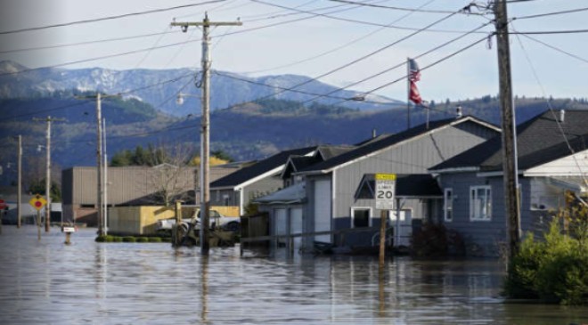
First Street’s findings were stark: that government had been substantially undercounting the risk of heavy rains that more than 100 million Americans lived under.
The nonprofit found that 51 percent of Americans live in areas where their risks of going through a “1-in-100 year” flood are twice the official estimate, while 21 percent can expect to see such a severe storm every 25 years. (To see the climate risk to 2050 for any freestanding home, click here.)
Read More:-Trump’s vulnerability on crime may have been exposed in Fox interview
And for many heavily populated cities, the odds are worse than that. New York, N.Y. can now expect a hundred year flood every 23 years; while Washington, D.C. and Dallas, Texas can expect one every 21 years, and Baltimore, Md. will face one every 14 years.
Because the hundred year flood represents the benchmark to which urban stormwater systems are typically calibrated, that means more than 100 million Americans “reside in a county where stormwater system failure is likely to occur today,” First Street authors wrote.
For some cities, the uptick in risk is particularly steep. Houston, Texas currently faces a more than fourfold increase in what used to be 100-year floods — the same odds as New York City.
But by 2053, Houston will have pulled ahead in their grim race — with that erstwhile 100-year flood now happening every 11 years.
The reason for the discrepancy is as simple to state as it is hard to fix: the federal government still doesn’t factor climate change into its long-term weather estimates.
Instead, NOAA built Atlas 14 on the core assumption that the underlying risks of devastating rains — however severe they might be — “do not change significantly over time,” as a 2022 federal audit found.
Under this system, weather behavior was presumed to be circular, such that “future climate conditions can be represented by the past observed precipitation,” the auditors found.
With such an expectation of stable long-term conditions — or what prediction scientists call “temporal stationarity” — a historic hundred year flood, for example, should continue to happen on average about every hundred years, and to do so with relatively consistent intensity.
Read More:-Russian diplomat flies to Beijing as Putin faces challenge to his power
That was a fairly safe bet for most of the climatologically stable 20th Century — and one which was already failing by century’s end.
Since every additional degree Fahrenheit of air temperature leads to just under 4 percent more water in the air, the dramatic rise in temperatures has come alongside a much higher instance of powerful, flood-causing rains.
A 2018 study that compared federal and state projections between 1961 and 2000 with the actual recorded rainfall totals found a persistent mismatch for 90 percent of areas studied.
Those findings raised the risk that stormwater infrastructure could be strictly built to code — and still “be under-designed for present and future climate conditions,” the scientists wrote in Environmental Research Letters.
That prediction seems to be coming true. Over the past 20 years, NOAA’s network of rain gauges have tracked 30 places which experienced multiple instances of what should have been “1-in-100 year events” as classified by Atlas 14, according to First Street.
And last summer, the U.S. saw five of what were predicted to be 1-in-1000, as deluges flooded St. Louis, Mo. and Dallas, Texas while stranding hikers in Death Valley, Calif.
To make prediction even harder, as a previous First Street study found, the master flood risk maps prepared by the Federal Emergency Management Agency don’t include precipitation at all.
Government data — which typically tracks the amount of rain that fell in a 24-hour period — also often obscured the new intensity in modern storms.
Also Read– Why You Never Want to See These Four Letters on Your Boarding Pass
While it is true to say that Fort Lauderdale, Fla. experienced more than two feet of rain in one day in mid-April, the First Street team noted, “it fails to acknowledge that … 26 inches of rain fell in just 6 hours.”
That new intensity means that even systems that could handle the new daily volume — if, say, the 26 inches had been evenly spread over 24 hours instead of compressed into six — risk being overwhelmed.
These are problems that NOAA itself is well aware of. The 2022 audit cited above came about as an early step in the ambitious and unprecedented process — also funded by the 2021 infrastructure package — of turning federal climate predictions from backward looking to forward looking.
The agency is currently working on proposed updates to Atlas 14 (called Atlas 15) to account for climate change — and to “develop precipitation frequency estimates for the entire U.S.”
But the agency doesn’t plan to have those results ready until 2027 — and design and construction for new infrastructure is already underway using the old numbers.
For First Street Foundation, that lack of data constitutes a considerable near-term market opportunity.
As The Hill has reported, the nonprofit has in the past decade carved out a unique business in predicting the likelihood that a given property will be impacted by extreme weather — like floods, fires, extreme heat, wind and now rain.
Also Read– New Law Gives You $8,000 for Free To Make These 5 Home Renovations
That has made them a crucial resource for banks, realty companies — and government agencies, many of which contract to use First Street’s peer-reviewed data in their own planning.
First Street’s new model “immediately allows for insights and informed actions today that otherwise would have to wait until NOAA’s completion of Atlas 15,” the company wrote in a press release.